I am an oceanography graduate specializing in geospatial science, spatial modelling, and environmental data analysis. My work applies GIS, remote sensing, and computational techniques to examine urban and coastal systems, with a focus on flood risk assessment and climate-related hazards. Using tools such as ArcGIS, Google Earth Engine, Python, and R, I develop data-driven models and spatial analyses that translate complex environmental data into actionable insights. I am particularly interested in integrating machine learning and multi-criteria analysis to support resilient urban planning and sustainable environmental management. My long-term goal is to pursue a PhD in geospatial and environmental systems and contribute to interdisciplinary research that bridges science, technology, and policy.
About Me
Research Interests
-
Remote Sensing & GIS ApplicationsSatellite data analysis, spatial modeling, and geospatial data management.
-
Oceanographic Data ScienceComputational and statistical approaches to marine and atmospheric datasets.
-
Coastal & Urban Flood Risk AssessmentIntegrated modeling, spatial analysis, and machine learning applications.
-
Climate Change & Environmental MonitoringImpacts on coastal ecosystems, agriculture, and trade vulnerability.
-
Geospatial Artificial Intelligence (GeoAI)Machine learning and predictive modeling for environmental systems.
Research Experience
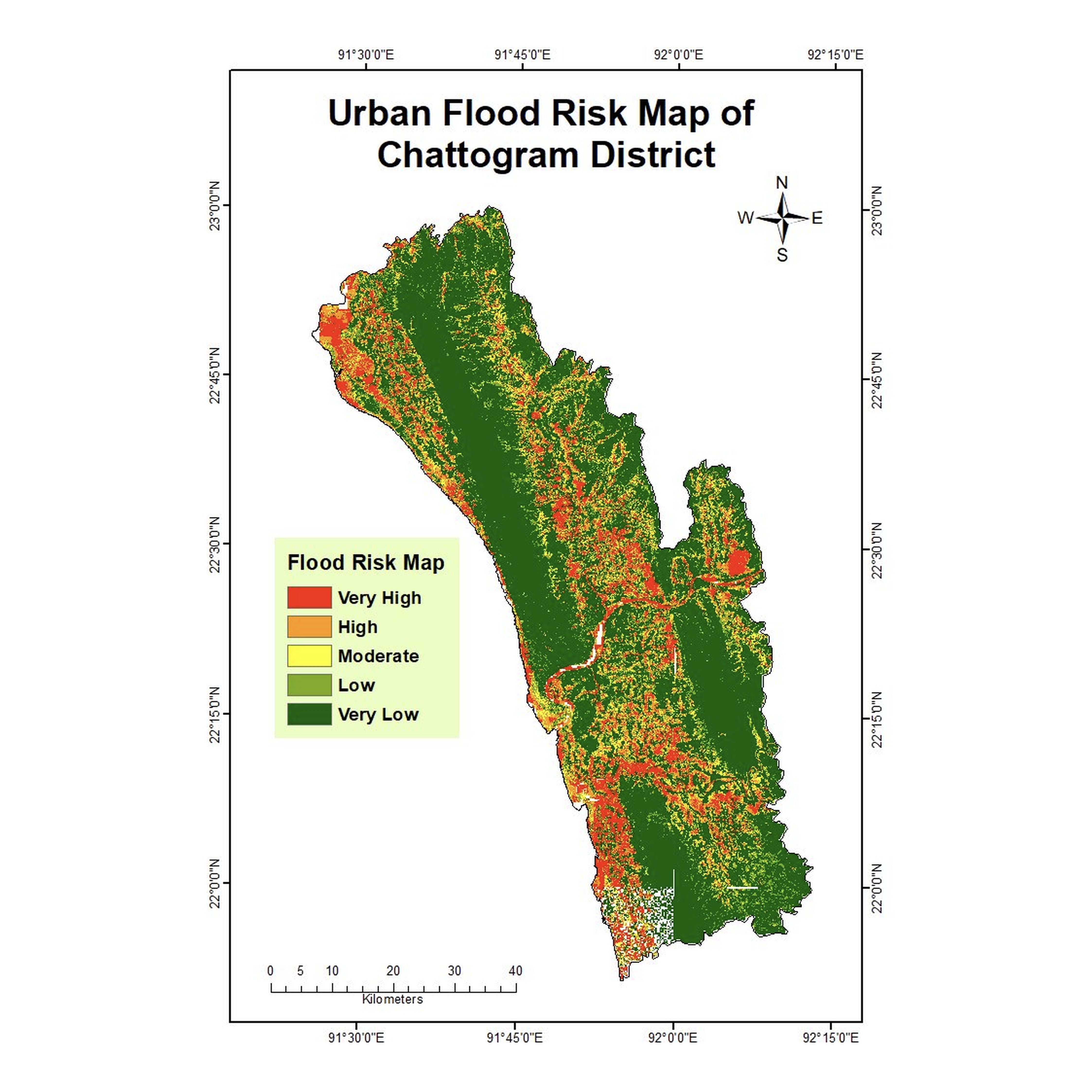
Integrated Modelling of Urban Flood Risk in Chattogram: Application of TOPSIS, Machine Learning and Spatial Analysis Approaches
Masters' Thesis | Supervisor: Dr Md Alamgir Kabir | Co-Supervisor: Abu Bokkar Siddique | Dec 2025
Summary
My master's thesis focuses on developing an integrated framework to evaluate urban flood risk in Chattogram, one of Bangladesh's most climate-vulnerable coastal cities. This research combines multi-criteria decision analysis (TOPSIS) with machine learning and spatial analysis to identify high-risk zones and the key environmental and socio-economic factors driving flood vulnerability.
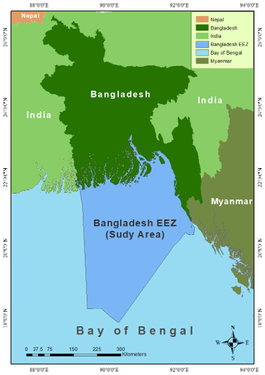
Spatial and Temporal Variability of PAR, Kd490, and SST in the Bangladesh EEZ (2016–2022)
Undergraduate Research Project | Supervisor: Abu Bokkar Siddique | Dec 2023
Summary
This study examines the spatial and temporal variability of Photosynthetically Available Radiation (PAR), Diffuse Attenuation Coefficient (Kd490), and Sea Surface Temperature (SST) across the Bangladesh EEZ from 2016 to 2022. Using MODIS-Aqua satellite data processed in SeaDAS and ArcGIS, it analyzes monthly and annual trends to assess their influence on marine ecosystems and support sustainable coastal management under changing climate conditions.
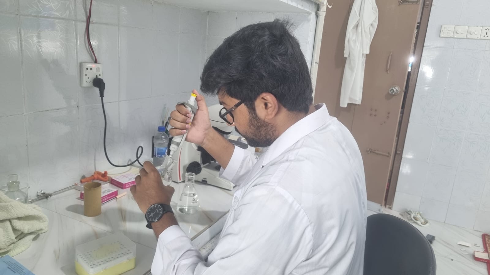
Growth, Observation, and Identification of Indigenous Marine Phytoplankton of the Bay of Bengal, Bangladesh
Internship Project | Bangladesh Fisheries Research Institute (BFRI), MFTS, Cox's Bazar | Mar 2025
Summary
This internship provided a comprehensive overview of a study focused on marine phytoplankton indigenous to the Bay of Bengal. The research encompassed the culture, growth observation, isolation, and identification of these microscopic organisms. The findings contribute meaningfully to enhancing marine biodiversity assessments and supporting effective management strategies for fisheries resources in the region.
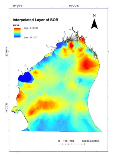
Quantitative Analysis of Annual Chlorophyll-a and Sea Surface Temperature Fluctuations in the Bay of Bengal
Mini Project under "Remote Sensing" coursework | Supervisor: Dr. Subrata Sarker | Jun 2023
Summary
This research investigates the spatial and temporal patterns of Chlorophyll-a and Sea Surface Temperature (SST) in the Bay of Bengal using monthly satellite observations from January to December 2020. Data from the NASA Ocean Color Web were processed using SNAP and ArcMap to assess regional and seasonal variability, with a focus on the Bangladesh coast. The findings contribute to a better understanding of marine ecosystem dynamics and support informed marine resource management.
Conference Papers
Coastal Urban Flood Risk Modelling in Chattogram: An Integrated Machine Learning and TOPSIS Approach
Spatial and Temporal Dynamics of PAR, Kd490, and SST in the Bangladesh EEZ (2016–2022)
Other Activities
Teaching Experience
Private Tutor & Coaching Instructor | Oct 2021 - Present
- Delivered personalized instruction to over 35+ students from Edexcel, IGCSE, O-Level, A-Level, and National Curriculum (Class 5–12), ensuring improved academic performance.
- Specialized in Higher Mathematics and Physics at the Higher Secondary level, simplifying complex concepts through structured lessons and problem-solving strategies.
- Provided comprehensive guidance in all core subjects at the Secondary level, adapting teaching methods to diverse learning styles.
- Conducted over 250+ classes at multiple coaching centres, developing classroom management and communication skills.
- Designed lesson plans, practice materials, and exam-focused sessions that prepared students for board exams and international curricula.
Field Works
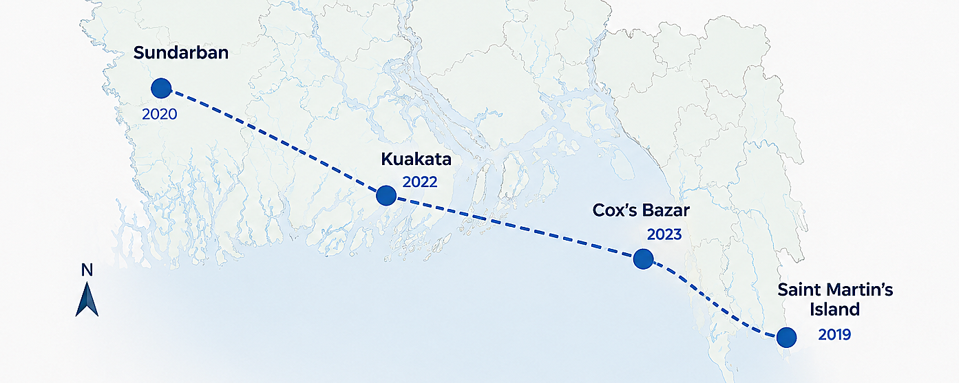

- Used quadrant and transect sampling techniques to collect various types of plastic materials from the beach
- Analyzed the collected samples and found that polythene and plastic bottles were the most prominent types of waste
- Explored the Bakkhali River estuary, observing various types of aquaculture, including: Seaweed farming, Oyster farming, Green mussel farming, Vetki and Khoral culture
- Collected water data using a mini CTD to measure key parameters like temperature, salinity, and conductivity

- Visited the Bangladesh Fisheries Research Institute (BFRI) to explore its research activities and facilities
- Acquired and processed CTD data to assess temperature, salinity, and conductivity
- Performed on-site water quality assessments using DO, pH, and turbidity meters
- Collected sediment samples with an Ekman grab sampler for textural analysis

- Collected sediment samples to analyze particle size distribution and organic matter content
- Conducted plankton sampling at Trikon Island to examine biodiversity and productivity levels
- Recorded temperature, salinity, and pH variations across different sampling sites
- Interacted with local fishermen at Dublar Char to gain insights into conservation issues
- Observed wild deer populations at Hiron Point as part of a biodiversity assessment

- Studied coral reef ecosystems and identified key biodiversity challenges
- Measured essential water quality parameters using a multiparameter instrument
- Visited the Fish Landing Center and Radiant Fish World to explore marine resources and research initiatives
Education
Master of Science (Thesis) in Oceanography
Shahjalal University of Science and Technology, Sylhet, Bangladesh
CGPA: 3.83 out of 4.00
Award: National Science and Technology Fellowship, Ministry of Science & Technology, Bangladesh
Bachelor of Science in Oceanography
Shahjalal University of Science and Technology, Sylhet, Bangladesh
CGPA: 3.66 out of 4.00
Higher Secondary Certificate: Science
New Govt. Degree College, Rajshahi
CGPA: 5.00 out of 5.00